Whose Country Am I On?
The continent of Australia has been occupied by humans for at least 60,000 years. The First Peoples or aboriginal and Torres Strait Islander custodians of this country are a complex and diverse group of people, made up of many different language and cultural entities and nations. These people have a continuous and evolving connection with our founding ancestors. As part of our evolving nationhood, Australia's First Nations people deserve to be recognized, acknowledged and respected. We have never had a treaty with our First Nations people, sovereignty has never been conceded by them. Conversely, the sovereignty of native peoples in Australia is not recognized in the Australian Constitution, unlike in other colonized countries (e.g. Canada and New Zealand). Reconciliation requires education, truth-telling, understanding and change. That is one of the purposes of this page. At the very least this page is aimed at helping to understand how we have come to work and play on this land and who had it before us.
The language groups of the Murray-Darling region can be found in the Indigenous Map of Australia (1996) at the Australian Institute of Aboriginal and Torres Strait Islander Studies website. Travelling upstream on the Murray River from the lakes and sea in South Australia, language groups include Ngarrindjeri (to approximately Murray Bridge/Mannum) then Meru to the east of Lake Victoria and the Lindsay River area. Then to the south of the Murray River to Swan Hill is the Latje Latje language group (including Mildura), almost to the Murrumbidgee River. Dadi Dadi and Wadi Wadi language groups then span the River Murray until Swan Hill, where in succession the Wemba Wemba and Baraba Baraba groups cover the country to Echuca. North of the Murray River, from Renmark to Wentworth and the Darling River is Barkindji; then Kureinji meets Dadi Dadi. From Echuca, language groups of the Murray River include Ngurraiillam and Yorta Yorta, Wiradjuri and Waveroo to Albury-Wodonga, then Jaitmatung and finally, Ngarigo in the high country of the Snowy Mountains.
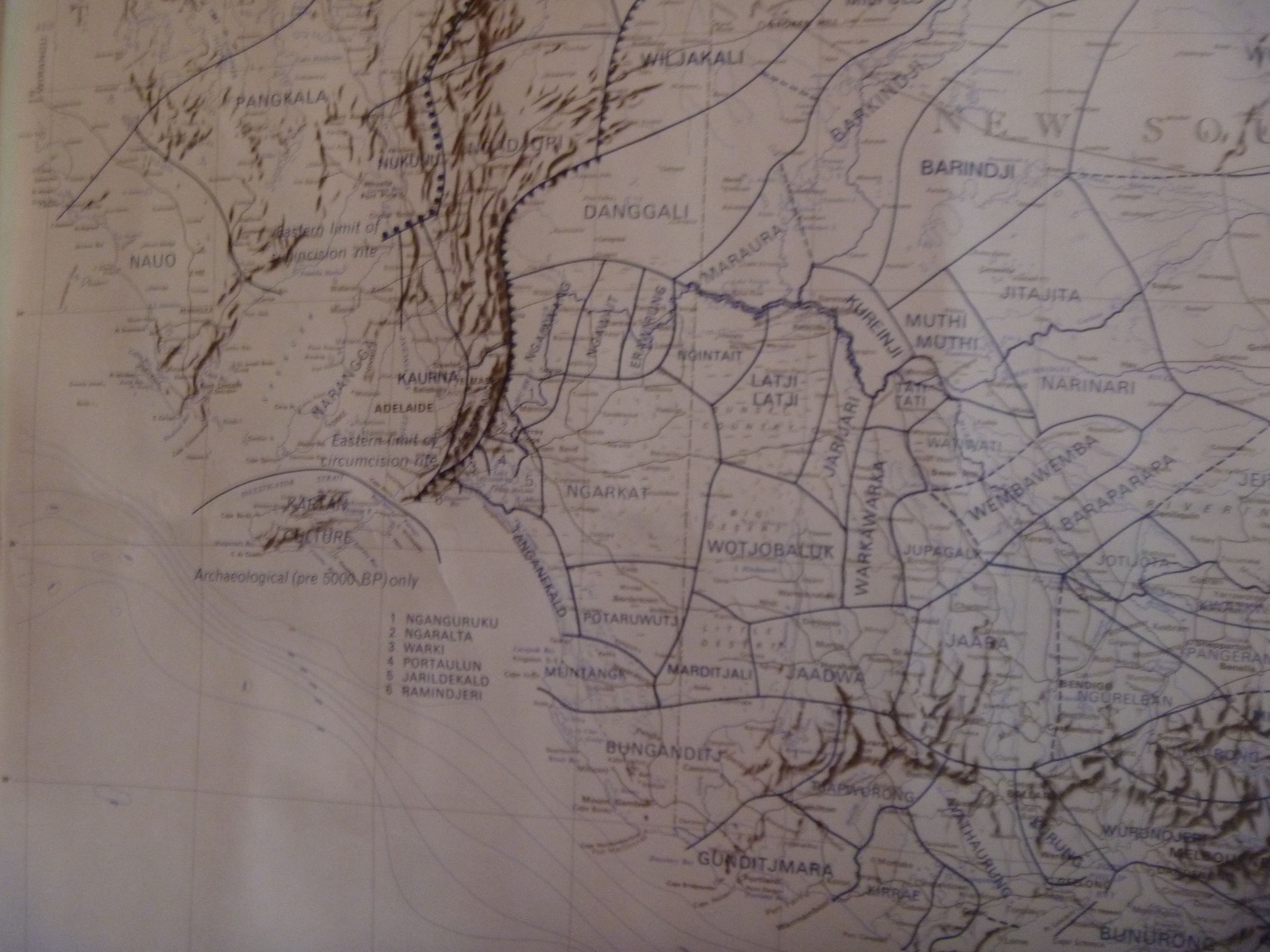
The South Australian Museum holds the Norman Barnett Tindale Collection, including the map Tribal Boundaries in Aboriginal Australia (1974), an excerpt of which is presented below. This shows an even more complex division of cultural and tribal boundaries. This map does not show the Ngarrindjeri, but rather the cultural groups that may have been arbitrarily and perhaps incorrectly classified as one. These include an area from Cape Jervis to Kingston SE and up the Murray River to the north of Murray Bridge and are the peoples of the Tanganekeld (Coorong) and Ramindjeri (Waitpinga to Goolwa), Warki, Portaulun and Jarildekald (around Lakes Alexandrina and Albert) and travelling north, Ngaralta (to beyond Murray Bridge) and Nganguruki (Mannum - Swan Reach area). The peoples of the Murray River further north include the Ngaiawang (Nildottie to Qualco, including Roonka and the Ngaut Ngaut rock shelter), Ngawait (including Overland Corner, Kingston OM, western side of Lake Bonney to near Loxton), Erawirung (Overland Corner/Rufus Creek, Loxton, Paringa) and Ngintait (north of Paringa to Cullullaraine, incl. Ned's Corner, Rufus River). More information on Tindale's map and photographs of aboriginal people of the Riverland can be found here.
Evidence of human habitation at Roonka (Devon Downs, Ngaut Ngaut) has been dated to 7,000 years ago. Human burial sites at Lake Mungo, also in the Murray-Darling Basin, have been dated to approximately 42,000 years ago. Many have walked this land before us and our First Nations people are directly and continuously linked to these ancestors.
Please note that this page is permanently under construction and it will contain errors or approximations that are entirely the responsibility of the author (Lindsay Dent). However the broad principles are correct or can reasonably be supported by published research.